The Pitcairn Islands (pronounced /ˈpɪtkɛən/; Pitkern: Pitkern Ailen), officially named the Pitcairn, Henderson, Ducie and Oeno Islands, are a group of four volcanic islands in the southern Pacific Ocean. The islands are a British overseas territory (formerly a British colony), the last remaining in the Pacific. The names of the islands are Pitcairn, Henderson, Ducie, and Oeno; only Pitcairn, the second largest, is inhabited.
The islands are best known as home of the descendants of the Bounty mutineers and the Tahitians who accompanied them, an event retold in numerous books and films. This story is still apparent in the surnames of many of the islanders. With only 50 inhabitants (from nine families), Pitcairn is also notable for being the least populated jurisdiction in the world (although it is not a sovereign nation). The United Nations Committee on Decolonisation includes the Pitcairn Islands on the United Nations list of Non-Self-Governing Territories.
Friday, July 31, 2009
Capitals of British territories
British overseas territories
The Valley, Anguilla
Hamilton, Bermuda
Rothera, British Antarctic Territory
Diego Garcia, British Indian Ocean Territory
Road Town, British Virgin Islands
George Town, Cayman Islands
Stanley, Falkland Islands
Gibraltar, GibraltarPlymouth (de jure), Brades (de facto), Montserrat
Adamstown, Pitcairn Islands
Jamestown, Saint Helena
- Georgetown, Ascension Island
- Edinburgh of the Seven Seas, Tristan da Cunha
Grytviken (de jure), King Edward Point (de facto), Sth Georgia & Sth Sandwich Islands
Episkopi Cantonment, Sovereign Base Areas of Akrotiri and Dhekelia
Cockburn Town, Turks and Caicos Islands
Crown dependencies
Saint Helier, Jersey
St. Peter Port, Guernsey
Douglas, Isle of Man
Constituent countries
London, England and the United Kingdom
Edinburgh, Scotland
Cardiff, Wales
Belfast, Northern Ireland
Svalbard
Svalbard is an archipelago in the Arctic Ocean north of mainland Europe, about midway between mainland Norway and the North Pole. It consists of a group of islands ranging from 74° to 81° north latitude, and from 10° to 35° east longitude. The archipelago is the northernmost part of Norway. Three islands are populated: Spitsbergen, Bear Island and Hopen. The largest settlement is Longyearbyen. The Spitsbergen Treaty (1920) recognised Norwegian sovereignty over Svalbard, and the 1925 Svalbard Act made Svalbard a full part of the Kingdom of Norway.
Capital: Longyearbyen
Barents Sea
The Barents Sea (Norwegian: Barentshavet, Russian: Баренцево море) is a part of the Arctic Ocean located north of Norway and Russia. It is a rather deep shelf sea (average depth 760 feet (230 m) and maximum depth 1,480 feet (450 m) ), bordered by the shelf edge towards the Norwegian Sea in the west, the island of Svalbard (Norway) in the northwest, and the islands of Franz Josef Land and Novaya Zemlya (Russia) in the northeast and east. Novaya Zemlya separates the Kara Sea from the Barents Sea. Known in the Middle Ages as the Murman Sea, the sea takes its current name from the Dutch navigator Willem Barentsz. Significant fossil fuel energy resources exist in the Barents Sea region.
Norwegian Sea
The Norwegian Sea (Norwegian: Norskehavet) is part of the North Atlantic Ocean, northwest of Norway, located between the North Sea (i.e. north of Scotland) and the Greenland Sea.
It adjoins the North Atlantic Ocean to the west and the Barents Sea to the northeast. In the southwest, it is separated from the Atlantic Ocean by a submarine ridge running between Iceland and the Faroe Islands. To the North, the Jan Mayen Ridge separates it from the Greenland Sea.
The Norwegian Sea and the Greenland Sea are sometimes collectively referred to as the Nordic Seas.
Strait of Gibraltar
The Strait of Gibraltar (Arabic: مضيق جبل طارق, Spanish: Estrecho de Gibraltar) is a narrow strait that connects the Atlantic Ocean to the Mediterranean Sea and separates Spain from Morocco. The name comes from Gibraltar, which in turn originates from the Arabic Jebel Tariq (meaning "Tariq's mountain"), albeit the Arab name for the Strait is Bab el-Zakat or "Gate of Charity". It is also known as the Straits of Gibraltar or STROG (Strait Of Gibraltar), in naval use and as "Pillars of Hercules "(Greek: Ηράκλειες Στήλες) in the ancient world.
Europe and Africa are separated by 14.24 km (7.7 nautical miles) of ocean at the strait's narrowest point. The strait depth ranges between 300 and 900 metres (980 and 3,000 ft) which possibly interacted with the lower mean sea level of the last major glaciation 20,000 years before present when the level of the sea was believed to be 110 to 120 meters (361 to 394 ft) lower. Ferries cross between the two continents every day in as little as 35 minutes. The Spanish side of the strait is protected under the El Estrecho Natural Park.
Channel Islands
The Channel Islands (Norman: Îles d'la Manche, French: Îles Anglo-Normandes or Îles de la Manche) are an archipelago in the English Channel, off the French coast of Normandy. They include two separate bailiwicks: the Bailiwick of Guernsey and the Bailiwick of Jersey. They are British Crown dependencies, but neither is part of the United Kingdom; rather they are considered the remnants of the Duchy of Normandy.[1] They have a total population of about 158,000. Their respective capitals, St. Peter Port and St. Helier, have populations of 16,488 and 28,310.
The Bailiwicks have been administered separately from each other since the late 13th century, and although those unacquainted with the islands often assume they form one political unit, common institutions are the exception rather than the rule. The two Bailiwicks have no common laws, no common elections, and no common representative body (although their politicians consult regularly). There is no common newspaper or radio station, but a common television station, ITV Channel Television.
Irish Sea
The Irish Sea (Irish: Muir Éireann or Muir Meann, Scottish Gaelic: Muir Eireann or Muir Mheann, Manx: Mooir Vannin, Welsh: Môr Iwerddon) also known as the Mann Sea or Manx Sea, separates the islands of Ireland and Great Britain. It is connected to the Atlantic Ocean in the south by St George's Channel, and in the north by the North Channel. Anglesey is the largest island within the Irish Sea, followed by the Isle of Man.
The sea is of significant economic importance to regional trade, shipping and transport, fishing and power generation in the form of wind power and nuclear plants. Annual traffic between the two islands amounts to over 12 million passengers and 17 million tonnes of traded goods.
Jersey
The Bailiwick of Jersey (pronounced /ˈdʒɜrzi/; Jèrriais: Jèrri) is a British Crown Dependency off the coast of Normandy, France. As well as the island of Jersey itself, the bailiwick includes the nearly uninhabited islands of the Minquiers, Écréhous, the Pierres de Lecq and other rocks and reefs. Together with the bailiwick of Guernsey it forms the grouping known as the Channel Islands. The defence of all these islands is the responsibility of the United Kingdom.[citation needed] However, Jersey is part of neither the UK nor the European Union; rather, like the Isle of Man, it is a separate possession of the Crown. Jersey belongs to the Common Travel Area.
Capital: Saint Helier
Isle of Man
The Isle of Man (pronounced /ˈmæn/; Manx: Ellan Vannin, pronounced [ˈɛlʲən ˈvanɪn]), or Mann (Manx: Mannin, [ˈmanɪn]), is a self-governing Crown dependency, located in the Irish Sea at the geographical centre of the British Isles. The head of state is Queen Elizabeth II, who holds the title of Lord of Mann. The Crown is represented by a Lieutenant Governor. The island is not part of the United Kingdom but foreign relations, defence, and ultimate good-governance of the Isle of Man are the responsibility of the government of the United Kingdom.
Inhabited for millennia, the island gradually became a Celtic-Norse community as the Norse settled there, starting about AD 850. This has left a legacy ranging from the Tynwald parliament to many local place names. After a period of alternating rule by the kings of England and Scotland, the Manx came under the feudal over-lordship of the English Crown. The lordship revested into the British Crown in 1764 but the island never became part of the United Kingdom and retained its status as an internally self-governing jurisdiction.
The Isle of Man is not a part of the European Union, but has a limited relationship concerning the free movement of goods.
Capital: Douglas (Doolish)
Guernsey
The Bailiwick of Guernsey (pronounced /ˈɡɜrnzi/; French: Bailliage de Guernesey) is a British Crown Dependency in the English Channel off the coast of Normandy.
As well as the island of Guernsey itself, it also includes Alderney, Sark, Herm, Jethou, Brecqhou, Burhou, Lihou and other islets. Although the defence of all these islands is the responsibility of the United Kingdom[2], Guernsey is not part of the UK but rather a separate possession of the Crown, comparable to the Isle of Man. Guernsey is also not part of the European Union. The island of Guernsey is divided into 10 parishes. Together with the Bailiwick of Jersey, it is included in the collective grouping known as the Channel Islands. Guernsey belongs to the Common Travel Area.
Capital: St Peter Port
Gibraltar
Gibraltar (pronounced /dʒɨˈbrɒltər/) is a self-governing British overseas territory located on the southern end of the Iberian Peninsula and Europe at the entrance of the Mediterranean overlooking the Strait of Gibraltar. The territory covers 6.843 square kilometres (2.642 sq mi) and shares a land border with Spain to the north. Gibraltar has historically been an important base for the British Armed Forces and is the site of a Royal Navy base.
A one-year investigation and analysis of 235 countries and territories by Jane’s Country Risk listed Gibraltar as the top stable and prosperous British Territory, in 5th position overall.[The sovereignty of Gibraltar has been a major bone of contention in Anglo-Spanish relations. Gibraltar was ceded by Spain to the Crown of Great Britain in perpetuity, under the 1713 Treaty of Utrecht, though Spain asserts a claim to the territory and seeks its returnThe overwhelming majority of Gibraltarians strongly oppose this, along with any proposal of shared sovereignty. The British government has stated that it is committed to respecting the Gibraltarians' wishes.
Capital: Gibraltar
Faroe Islands
The Faroe Islands or Faeroe Islands or simply Faroe(s) or Faeroes (Faroese: Føroyar, Danish: Færøerne) are an island group situated between the Norwegian Sea and the North Atlantic Ocean, approximately half way between Scotland and Iceland. The Faroe Islands are a part of the Kingdom of Denmark, along with Denmark proper and Greenland.
The Faroe Islands have been an autonomous province of Denmark since 1948. Over the years, the Faroese have taken control of most matters. Some areas still remain the responsibility of Denmark, though, such as military defence, foreign affairs and law.
The Faroes have close traditional ties to Iceland, Norway, Shetland, Orkney, the Outer Hebrides and Greenland. The archipelago was politically detached from Norway in 1814. The Faroes are represented in the Nordic Council as a part of the Danish delegation.
Capital: Tórshavn
Akrotiri and Dhekelia
The Sovereign Base Areas of Akrotiri and Dhekelia are two UK-administered areas on the island of Cyprus that comprise the Sovereign Base Areas military bases of the United Kingdom. The bases were retained by the UK following the granting of independence and the eventual transition of Cyprus from a crown colony to an independent sovereign state. The United Kingdom demanded and succeeded in continuing to occupy a portion of Cyprus in the form of military bases because of the strategic location of Cyprus in the Mediterranean Sea in pursuit of UK interests.
The bases are split into Akrotiri (Greek: Ακρωτήρι; Turkish: Agrotur, along with Episkopi Garrison, is part of an area known as the Western Sovereign Base Area or WSBA) and Dhekelia (Greek: Δεκέλεια; Turkish: Dikelya, along with Ayios Nikolaos, is part of the Eastern Sovereign Base Area or ESBA).
Capital: Episkopi (administrative centre)
Åland Islands
The Åland Islands (Swedish pronunciation: [ˈoːland]; Finnish: Ahvenanmaa) form an archipelago in the Baltic Sea. It is situated at the entrance to the Gulf of Bothnia and forms an autonomous, demilitarized, monolingually Swedish-speaking administrative province, region and historical province of Finland. It is the smallest province of Finland, comprising 0.5% of Finland's population and 0.49% of land area.
The islands consist of the main island Fasta Åland (literally "Firm Åland"), where 90% of the population resides,[2] and an archipelago to the east that consists of over 6,500 skerries and islands. Fasta Åland is separated from the coast of Sweden by forty kilometres (twenty-five miles) of open water to the west. In the east, the Åland archipelago is virtually contiguous with the Finnish Archipelago Sea. Åland's only land border is located on the uninhabited skerry of Märket,[3] which it shares with Sweden.
Due to Åland's autonomous status, the powers exercised at the provincial level by representatives of the central state administration in the rest of Finland are largely exercised by the Government of Åland in Åland.
Capital: Mariehamn
Principality of Sealand
The Principality of Sealand is a micronation located on HM Fort Roughs, a former World War II Maunsell Sea Fort in the North Sea 10 km (six miles) off the coast of Suffolk, England.
Since 1967, the facility has been occupied by former radio broadcaster British Army Major Paddy Roy Bates; his associates and family claim that it is an independent sovereign state. External commentators generally classify Sealand as a micronation.[2] It has been described as the world's smallest nation.[3] Sealand is not currently officially recognized as a sovereign state by any United Nations member.
Capital: HM Fort Roughs
Transnistria
Transnistria, also known as Trans-Dniester, Transdniestria, and Pridnestrovie is a disputed region in Eastern Europe. Since its declaration of independence in 1990, followed by the War of Transnistria in 1992, it is governed by the unrecognized Pridnestrovian Moldavian Republic (PMR), which claims the left bank of the river Dniester and the city of Bendery within the former Moldavian SSR. The modern Republic of Moldova does not recognize the secession and considers PMR-controlled territories to be a part of Moldova's sovereign territory.[2][3][4][5][6]
Transnistria is located mostly in a strip between the Dniester River and Ukraine. After the dissolution of the USSR, Transnistria declared independence, leading to a war with Moldova that started in March 1992 and was concluded by the ceasefire of July 1992. As part of that agreement, a three-party (Russia, Moldova, PMR) Joint Control Commission supervises the security arrangements in the demilitarized zone, comprising 20 localities on both sides of the river. Although the ceasefire has held, the territory's political status remains unresolved: De jure part of Moldova, Transnistria is a de facto independent state.[7][8][9][10] It is organised as a presidential republic, with its own government, parliament, military, police, postal system, and currency. Its authorities have adopted a constitution, flag, national anthem, and a coat of arms.
Transnistria is sometimes compared with other post-Soviet frozen conflict zones such as Nagorno-Karabakh, Abkhazia, and South Ossetia.[11][12] The latter two - which are recognized only by Russia and each other - have recognised Transnistria as an independent state and plan to establish diplomatic relations in return for Transnistria's recognition of them (see Community for Democracy and Human Rights).
Capital: Tiraspol
Nagorno-Karabakh
Lesser Caucasus mountains. The region is mostly mountainous and afforested and has an area of 8,223 square kilometres (3,175 sq mi).
The region is de jure part of Azerbaijan, but most of it is de facto governed by the internationally unrecognized Nagorno-Karabakh Republic. Since the end of the Nagorno-Karabakh War in 1994, representatives of the governments of Armenia and Azerbaijan have been holding peace talks mediated by the OSCE Minsk Group on the region's disputed status.
South Ossetia
South Ossetia (pronounced /ɒˈsɛtɪə/[1] or /ɒˈsiːʃə/[2]; Ossetic: Хуссар Ирыстон, Xussar Iryston; Russian: Южная Осетия, Yuzhnaya Osetiya; Georgian: სამხრეთი ოსეთი, Samxreti Oseti) is a disputed region in the South Caucasus, located on the territory of the South Ossetian Autonomous Oblast within the former Georgian Soviet Socialist Republic.
In the Soviet era South Ossetia was the "South Ossetian Autonomous Oblast", a dominantly ethnic enclave, within the Georgian Soviet Socialist Republic (Georgian SSR).[3]
The Republic of South Ossetia declared its independence from Georgia in 1991 during the Georgian-Ossetian conflict.[4] However, the entity remained unrecognized, save by fellow break-away republics Abkhazia and Transnistria. Since the 2008 South Ossetian war, during which the republic gained full control of the territory of the former Autonomous Oblast, Russia and Nicaragua have recognized South Ossetia's independence. Georgia does not recognize the secession of the province nor its existence as an autonomous entity, and considers it to be a part of the Shida Kartli region within its sovereign territory. The United States, European Union, along with many other countries consider the territory of South Ossetia a part of Georgia and do not recognize South Ossetia as an independent state. Since 28 August 2008, Georgia has been considering the region to be a "Russian-occupied territory."
Capital: Tskhinvali
Northern Cyprus
The Turkish Republic of Northern Cyprus (TRNC) (Turkish: Kuzey Kıbrıs Türk Cumhuriyeti, KKTC), commonly called Northern Cyprus or North Cyprus [4] (Turkish: Kuzey Kıbrıs), is a de facto independent republic[5][6][7] located in the north of Cyprus. The TRNC declared its independence in 1983, nine years after a Greek Cypriot coup attempting to annex the island to Greece triggered an invasion by Turkey. It has received diplomatic recognition only from Turkey, on which it has become dependent for economic, political and military support. The rest of the international community, including the United Nations and European Union, recognises the sovereignty of the Republic of Cyprus over the territory of the TRNC.
Kosovo
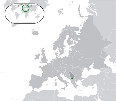
Kosovo (Albanian: Kosova, Kosovë; Serbian: Косово or Косово и Метохија, Kosovo or Kosovo i Metohija[6]) is a disputed region in the Balkans. Its majority is governed by the partially-recognised Republic of Kosovo (Albanian: Republika e Kosovës), a self declared independent state which has de facto control over the territory; the exceptions are some Serb enclaves. Serbia does not recognise the secession of Kosovo and considers it a United Nations-governed entity within its sovereign territory, the Autonomous Province of Kosovo and Metohija (Serbian: Аутономна Покрајина Косово и Метохија, Autonomna Pokrajina Kosovo i Metohija), according to the Constitution of Serbia (2006).[7]
Kosovo is landlocked and bordered by Macedonia to the south, Albania to the west, the region of Central Serbia to the north and east, and Montenegro to the Northwest. The largest city and the capital of Kosovo is Pristina (alternatively spelled Prishtina or Priština), while other cities include Peja (Peć), Prizren, Gjakova (Đakovica) and Mitrovica.
Capital: Pristina
Abkhazia
Abkhazia (Abkhaz: Аҧсны Apsny, Georgian: აფხაზეთი Apkhazeti or Abkhazeti, Russian: Абха́зия Abkhazia) is a disputed region on the eastern coast of the Black Sea. Since its declaration of independence from Georgia in 1991 during the Georgian–Abkhaz conflict, it is governed by the partially-recognized Republic of Abkhazia.
Capital: Sukhumi
Subscribe to:
Posts (Atom)