Monday, August 3, 2009

Italy


Italy /ˈɪtəli/ (help·info) (Italian: Italia), officially the Italian Republic (Italian: Repubblica Italiana), is a country located on the Italian Peninsula in Southern Europe and on the two largest islands in the Mediterranean Sea, Sicily and Sardinia. Italy shares its northern, Alpine boundary with France, Switzerland, Austria and Slovenia. The independent states of San Marino and the Vatican City are enclaves within the Italian Peninsula, and Campione d'Italia is an Italian exclave in Switzerland.
The land known as Italy today has been the cradle of many European cultures and peoples, such as the Etruscans and the Romans, and later was the birthplace of the University, the Renaissance that began in Tuscany and spread all over Europe, Vitruvian Man, modern science and astronomy, heliocentrism and opera. Italy's capital, Rome, was for centuries the center of Western civilization. Italy possessed a colonial empire from the second half of the nineteenth century to the mid-twentieth century.
Today, Italy is a democratic republic and a developed country with the eighth-highest quality of life index rating in the world.[6] It is a founding member of what is now the European Union, having signed the Treaty of Rome in 1957, and it is a founding member of the North Atlantic Treaty Organization (NATO). It is a member of the G8, having the world's seventh-largest nominal GDP, and is also a member state of the Organisation for Economic Co-operation and Development (OECD), the World Trade Organization (WTO), the Council of Europe, the Western European Union, and the Central European Initiative. Italy is a Schengen state. It has the world's seventh-largest defence budget and shares NATO's nuclear weapons. On 1 January 2007, Italy began a two-year term as a non-permanent member of the United Nations Security Council.


Capital(and largest city)
Rome 41°54′N 12°29′E / 41.9°N 12.483°E / 41.9; 12.483
Official languages
Italian1
Ethnic groups ([1])
94.2% Italian1.94% Romanian, Albanian, Ukrainian1.34% African0.92% Asian0.46% South American1.14% Other
Demonym
Italian
Government
Parliamentary republic
-
President
Giorgio Napolitano
-
Prime Minister
Silvio Berlusconi
Legislature
Parliament
-
Upper House
Senate
-
Lower House
Chamber of Deputies
Formation
-
Unification
17 March 1861
-
Republic
2 June 1946
EU accession
25 March 1957 (founding member)
Area
-
Total
301,338 km2 (71st)116,346 sq mi
-
Water (%)
2.4
Population
-
2008 estimate
60,067,554[2] (23rd)
-
2001 census
57,110,144
-
Density
199.3/km2 (54th)516.3/sq mi
GDP (PPP)
2009 estimate
-
Total
$1,815 billion[3] (10th)
-
Per capita
$29,273[3] (27th)
GDP (nominal)
2009 estimate
-
Total
$2.314 billion[3] (7th)
-
Per capita
$33,253[3] (21st)
Gini (2000)
36 (medium)
HDI (2006)
▲ 0.945[4] (high) (19th)
Currency
Euro ()2 (EUR)
Time zone
CET (UTC+1)
-
Summer (DST)
CEST (UTC+2)
Drives on the
right
Internet TLD
.it3
Calling code
39


Germany comprises 16 states (Bundesländer)

Germany


Germany (pronounced /ˈdʒɜrməni/ ( listen)), officially the Federal Republic of Germany (German: Bundesrepublik Deutschland, pronounced [ˈbʊndəsʁepuˌbliːk ˈdɔʏtʃlant] ( listen)),[5] is a country in Central Europe. It is bordered to the north by the North Sea, Denmark, and the Baltic Sea; to the east by Poland and the Czech Republic; to the south by Austria and Switzerland; and to the west by France, Luxembourg, Belgium, and the Netherlands. The territory of Germany covers 357,021 square kilometers (137,847 sq mi) and is influenced by a temperate seasonal climate. With 82 million inhabitants, it accounts for the largest population among the member states of the European Union and is home to the third-largest number of international migrants worldwide.[6]
A region named Germania inhabited by several Germanic peoples has been known and documented before AD 100. Beginning in the 10th century, German territories formed a central part of the Holy Roman Empire that lasted until 1806. During the 16th century, northern Germany became the centre of the Protestant Reformation. As a modern nation-state, the country was first unified amidst the Franco-Prussian War in 1871. In 1949, after World War II, Germany was divided into two separate states—East Germany and West Germany—along the lines of Allied occupation.[7] The two states were unified in 1990. West Germany was a founding member of the European Community (EC) in 1957, which became the European Union in 1993. It is part of the Schengen zone and adopted the European currency, the euro, in 1999.
Germany is a federal parliamentary republic of sixteen states (Länder). The capital and largest city is Berlin. Germany is a member of the United Nations, NATO, G8 and the OECD. It is a major economic power with the world's fourth largest economy by nominal GDP and the fifth largest in purchasing power parity. It is the largest exporter and second largest importer of goods. In absolute terms, Germany allocates the second biggest annual budget of development aid in the world,[8] while its military expenditure ranked sixth.[9] The country has developed a high standard of living and established a comprehensive system of social security. It holds a key position in European affairs and maintains a multitude of close partnerships on a global level.[10] Germany is recognised as a scientific and technological leader in several fields.


Capital(and largest city)
Berlin 52°31′N 13°23′E / 52.517°N 13.383°E / 52.517; 13.383
Official languages
German[1]
Ethnic groups
91.5% German, 2.4% Turkish, 6.1% other[1]
Demonym
German
Government
Federal Parliamentary republic
-
President
Horst Köhler (CDU)
-
Chancellor
Angela Merkel (CDU)
Formation
-
Holy Roman Empire
962
-
German Empire
18 January 1871
-
Federal Republic
23 May 1949
-
Reunification
3 October 1990
EU accession
25 March 1957
Area
-
Total
357,021 km2 (63rd)137,847 sq mi
-
Water (%)
2.416
Population
-
December 31, 2008 estimate
82,060,000[2] (14th)
-
Density
230/km2 (36th)596/sq mi
GDP (PPP)
2008 estimate
-
Total
$2.910 trillion[3] (5th)
-
Per capita
$35,442[3] (21st)
GDP (nominal)
2008 estimate
-
Total
$3,667 trillion[3] (4th)
-
Per capita
$44,660[3] (19th)
Gini (2000)
28.3 (low)
HDI (2006)
▲ 0.940[4] (high) (23rd)
Currency
Euro () (EUR)
Time zone
CET (UTC+1)
-
Summer (DST)
CEST (UTC+2)
Internet TLD
.de
Calling code
49


Baden-Württemberg
Stuttgart
35,752
10,717,000
Bavaria
Munich
70,549
12,444,000
Berlin
Berlin
892
3,400,000
Brandenburg
Potsdam
29,477
2,568,000
Bremen
Bremen
404
663,000
Hamburg
Hamburg
755
1,735,000
Hesse
Wiesbaden
21,115
6,098,000
Mecklenburg-Vorpommern
Schwerin
23,174
1,720,000
Lower Saxony
Hanover
47,618
8,001,000
North Rhine-Westphalia
Düsseldorf
34,043
18,075,000
Rhineland-Palatinate
Mainz
19,847
4,061,000
Saarland
Saarbrücken
2,569
1,056,000
Saxony
Dresden
18,416
4,296,000
Saxony-Anhalt
Magdeburg
20,445
2,494,000
Schleswig-Holstein
Kiel
15,763
2,829,000
Thuringia
Erfurt
16,172
2,355,000

Sunday, August 2, 2009

Map of Australia


Australia (pronounced /əˈstreɪljə, ɒˈstreɪljə/[7], or formally /ɔːˈstreɪliə/), officially the Commonwealth of Australia, is a country in the southern hemisphere comprising the mainland, which is both the world's smallest continent and the world's largest island,[8] the island of Tasmania, and numerous other islands in the Indian and Pacific Oceans.N4 Australia is the only place that is simultaneously considered a continent, a country and an island. Neighbouring countries include Indonesia, East Timor and Papua New Guinea to the north, the Solomon Islands, Vanuatu and New Caledonia to the north-east and New Zealand to the southeast.
For around 40,000 years before European settlement commenced in the late 18th century, the Australian mainland and Tasmania were inhabited by around 250 individual nations[9] of indigenous Australians.[10] After sporadic visits by fishermen from the immediate north, and European discovery by Dutch explorers in 1606,[11] the eastern half of Australia was claimed by the British in 1770 and initially settled through penal transportation to the colony of New South Wales, founded on 26 January 1788. The population grew steadily in the following years; the continent was explored, and during the 19th century another five largely self-governing Crown Colonies were established.
On 1 January 1901, the six colonies became a federation, and the Commonwealth of Australia was formed. Since Federation, Australia has maintained a stable liberal democratic political system and remains a Commonwealth realm. The population is just over 21.7 million, with approximately 60% concentrated in and around the mainland state capitals of Sydney, Melbourne, Brisbane, Perth, and Adelaide. The nation's capital city is Canberra, located in the Australian Capital Territory (ACT).
Technologically advanced and industrialised, Australia is a prosperous multicultural country and has excellent results in many international comparisons of national performance such as health care, life expectancy, quality-of-life, human development, public education, economic freedom, and the protection of civil liberties and political rights.[12] Australian cities also routinely rank among the world's highest in terms of livability, cultural offerings, and quality of life. It is a member of the United Nations, G-20 major economies, Commonwealth of Nations, ANZUS, OECD, and the WTO.


Capital
Canberra 35°18′S 149°08′E / 35.3°S 149.133°E / -35.3; 149.133
Largest city
Sydney
Official languages
NoneN2
National language
English (de facto)N2
Ethnic groups
92% white,7% Asian,1% Aboriginal and other[1]
Demonym
Australian,Aussie[2][3] (colloquial)
Government
Federal parliamentary democracy and constitutional monarchy, see Government of Australia
-
Monarch
Queen Elizabeth II
-
Governor-General
Quentin Bryce
-
Prime Minister
Kevin Rudd
Independence
from the United Kingdom
-
Constitution
1 January 1901
-
Statute of Westminster
11 December 1931
-
Statute of Westminster Adoption Act
9 October 1942 (with effect from 3 September 1939)
-
Australia Act
3 March 1986
Area
-
Total
7,686,850 km2 (6th)2,967,909 sq mi
-
Water (%)
0.897
Population
-
2009 estimate
21,807,000[4] (53rd)
-
2006 census
19,855,288[5]
-
Density
2.833/km2 (232nd)7.3/sq mi
GDP (PPP)
2008 estimate
-
Total
US$795.305 billion[6] (17th)
-
Per capita
US$37,298[6] (15th)
GDP (nominal)
2008 estimate
-
Total
US$1,010 billion[6] (15th)
-
Per capita
US$47,400[6] (13th)
HDI (2006)
▲ 0.965 (high) (4th)
Currency
Australian dollar (AUD)
Time zone
variousN3 (UTC+8 to +10.5)
-
Summer (DST)
variousN3 (UTC+9 to +11.5)
Drives on the
left
Internet TLD
.au
Calling code
61

Regions of France


Madagascar

Madagascar, or Republic of Madagascar (older name Malagasy Republic, French: République malgache), is an island nation in the Indian Ocean off the southeastern coast of Africa. The main island, also called Madagascar, is the fourth-largest island in the world, and is home to 5% of the world's plant and animal species, of which more than 80% are endemic to Madagascar.[citation needed] They include the lemur infraorder of primates, the carnivorous fossa, three bird families and six baobab species. Two thirds of the population live below the international poverty line of US$1.25 a day.


Capital(and largest city)
Antananarivo 18°55′S 47°31′E / 18.917°S 47.517°E / -18.917; 47.517
Official languages
Malagasy, French, English1
Demonym
Malagasy[1]
Government
Caretaker government
-
President of the High Authority of Transition
Andry Rajoelina
-
Prime Minister
Monja Roindefo
Independence
from France
-
Date
26 June 1960
Area
-
Total
587,041 km2 (45th)226,597 sq mi
-
Water (%)
0.13%
Population
-
July 2008 estimate
20,042,551[2] (55th)
-
1993 census
12,238,914
-
Density
33/km2 (171st)86/sq mi
GDP (PPP)
2008 estimate
-
Total
$19.722 billion[3]
-
Per capita
$975[3]
GDP (nominal)
2008 estimate
-
Total
$9.254 billion[3]
-
Per capita
$457[3]
Gini (2001)
47.5 (high)
HDI (2007)
▲ 0.533 (medium) (143rd)
Currency
Malagasy ariary (MGA)
Time zone
EAT (UTC+3)
-
Summer (DST)
not observed (UTC+3)
Drives on the
right
Internet TLD
.mg
Calling code
261

Libya


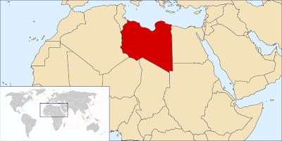
Libya (Arabic: ليبيا ‎ Lībiyā pronunciation (help·info); Libyan vernacular: Lībya pronunciation (help·info); Amazigh: ), officially the Great Socialist People's Libyan Arab Jamahiriya ( الجماهيرية العربية الليبية الشعبية الإشتراكية العظمى ‎ Al-Jamāhīriyyah al-ʿArabiyyah al-Lībiyyah aš-Šaʿbiyyah al-Ištirākiyyah al-ʿUẓmā pronunciation (help·info)), is a country located in North Africa. Bordering the Mediterranean Sea to the north, Libya lies between Egypt to the east, Sudan to the southeast, Chad and Niger to the south, and Algeria and Tunisia to the west.
With an area of almost 1.8 million square kilometres (700,000 sq mi), 90% of which is desert, Libya is the fourth largest country in Africa by area, and the 17th largest in the world.[3] The capital, Tripoli, is home to 1.7 million of Libya's 5.7 million people. The three traditional parts of the country are Tripolitania, the Fezzan, and Cyrenaica. Libya has the second highest GDP (PPP) per capita of Africa, behind Equatorial Guinea. This is largely due to its large petroleum reserves and low population.[4][5]
The flag of Libya consists of a green field with no other characteristics. It is the only national flag in the world with just one color and no design, insignia, or other details.

Capital(and largest city)
Tripoli 32°54′N 13°11′E / 32.9°N 13.183°E / 32.9; 13.183
Official languages
Arabic (native)[citation needed]
Demonym
Libyan
Government
Jamahiriya
-
Leader and Guide of the Revolution
Muammar al-Gaddafi
-
Secretary General of the General People's Congress
Imbarek Shamekh
-
Prime Minister
Baghdadi Mahmudi
Independence
-
Relinquished by Italy
10 February 1947
-
From France/United Kingdom under United Nations Trusteeship
24 December 1951
Area
-
Total
1,759,541 km2 (17th)679,359 sq mi
-
Water (%)
negligible
Population
-
estimate
6,173,579 (July 2008)[1] (105th)
-
2006 census
5,670,6881
-
Density
3.2/km2 (218th)8.4/sq mi
GDP (PPP)
2008 estimate
-
Total
$90.251 billion[2]
-
Per capita
$14,533[2] (55th)
GDP (nominal)
2008 estimate
-
Total
$100.071 billion[2]
-
Per capita
$16,114[2] (43rd)
HDI (2008)
▲0.840 (high) (52nd)
Currency
Dinar (LYD)
Time zone
EET (UTC+2)
Drives on the
right
Internet TLD
.ly
Calling code
218

Liberia

Liberia /laɪˈbɪəriə/ (help·info), officially the Republic of Liberia, is a country on the west coast of Africa, bordered by Sierra Leone, Guinea, Côte d'Ivoire, and the Atlantic Ocean. As of the 2008 Census, the nation is home to 3,476,608 people and covers 111,369 square kilometres (43,000 sq mi).[2] Its capital is Monrovia. Liberia has a hot equatorial climate with most rainfall arriving in summer with harsh harmattan winds in the dry season. Liberia's populated Pepper Coast is composed of mostly mangrove forests while the sparsely populated inland is forested, later opening to a plateau of drier grasslands.
The history of Liberia is unique among African nations, notably because of its relationship with the United States. It is one of the few countries in Africa, and the only country in West Africa, without roots in the European Scramble for Africa; although Liberians had contact with European explorers and traders briefly between 16th to 18th centuries, Liberia did not exist as a nation state until it was colonized by freed slaves from the United States. These freed slaves formed an elite group in Liberian society, and, in 1847, formed a government based on that of the United States, naming their capital city after James Monroe, the fifth president of the United States. This government was overthrown by a military-led coup in 1980, which marked the beginning of a period of instability and civil war that left hundreds of thousands of people dead and devastated the country's economy.
Today, Liberia is recovering from the lingering effects of this decades-long civil war. Its economy is based heavily on subsistence agriculture, manufacturing, and its many ports. Liberia is one of the poorest countries in Africa; nevertheless, the country has achieved economic growth, largely thanks to foreign investment.


Capital(and largest city)
Monrovia 6°19′N 10°48′W / 6.317°N 10.8°W / 6.317; -10.8
Official languages
English
Demonym
Liberian
Government
Republic
-
President of Liberia
Ellen Johnson-Sirleaf
-
Vice-President of Liberia
Joseph Boakai
-
Chief Justice
Johnnie Lewis
Formation
by African-Americans
-
ACS colonies consolidation
1821-1842
-
Independence (from the United States)
26 July 1847
Area
-
Total
111,369 km2 (103rd)43,000 sq mi
-
Water (%)
13.514
Population
-
2008 census
3,476,608 (130th)
-
Density
29/km2 (180th)75/sq mi
GDP (PPP)
2008 estimate
-
Total
$1.469 billion[1]
-
Per capita
$372[1]
GDP (nominal)
2008 estimate
-
Total
$836 million[1]
-
Per capita
$212[1]
HDI (2008)
▲0.364 (low) (176)
Currency
Liberian dollar1 (LRD)
Time zone
GMT
Drives on the
right
Internet TLD
.lr
Calling code
231